



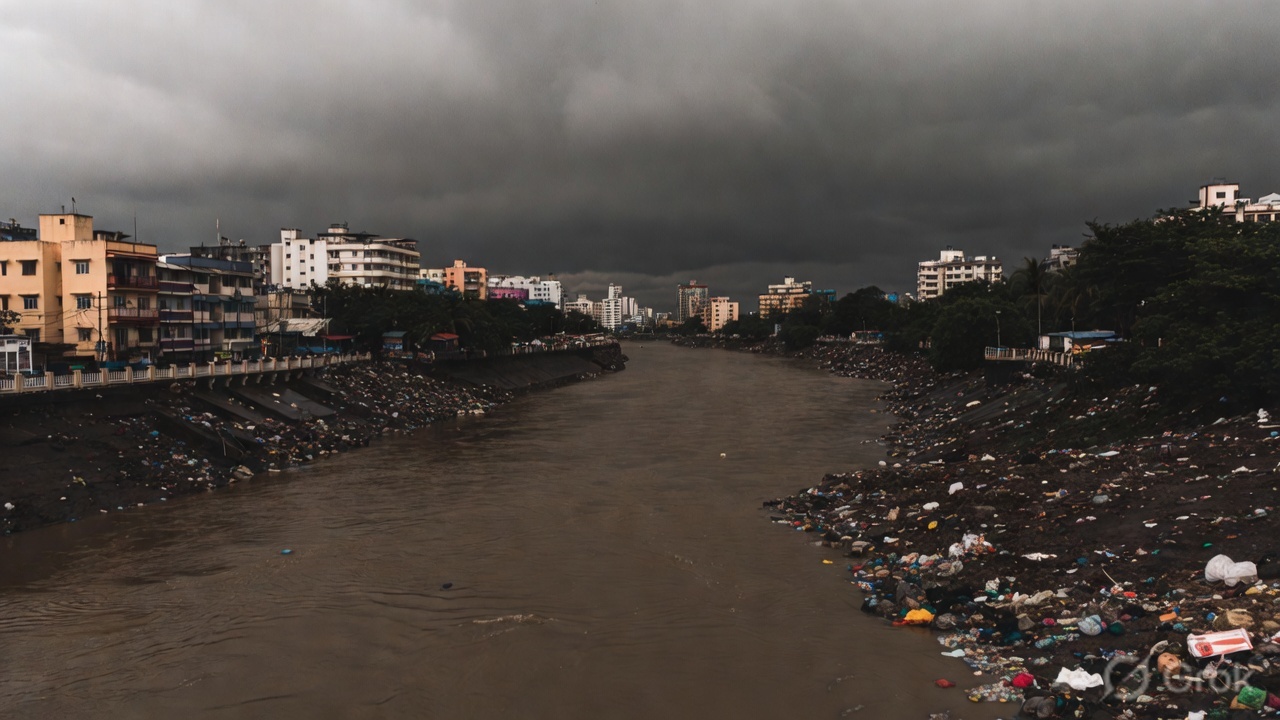
There is a moment, usually in late July, when Mumbai holds its breath. The rain hammers down in sheets. The streets flood. And somewhere beneath the noise of a city of 20 million people, a small and battered river quietly decides how bad the next few hours will be.
The Mithi River is 17.8 kilometres long. It begins at Powai Lake, slides through some of the city’s most densely populated neighbourhoods and empties into Mahim Creek. By the standards of India’s great rivers, it barely qualifies as a waterway. Yet what happens inside that narrow channel shapes the fate of millions of Mumbaikars every monsoon season.
This is the story of a river that Mumbai forgot, and the question of whether it is too late to remember.
From Marshland to Drain
The Mithi was not always an afterthought. For most of Mumbai’s history, the river and its surrounding wetlands served as a natural flood buffer. The low-lying areas of Kurla, Dharavi and Mahim were once marsh and mangrove. Fishing communities built their lives along these tidal waters. The ecology worked because nobody had yet decided it needed to be improved.
Then came the city.
From the 1970s onwards, Mumbai expanded aggressively. The changes came quickly and without meaningful resistance:
- Industrial estates moved in along the river’s banks
- Informal settlements followed, narrowing the natural channel
- Solid waste found its way into the water
- Factories discharged effluents with little oversight
- Mangroves, which once filtered the water and steadied the banks, were cleared for construction
By the 1990s, the Mithi had effectively stopped being a river. It had become a drain. A slow, overloaded and heavily polluted drain running through the heart of one of the world’s most populous cities.
The Day Mumbai Discovered the Cost
On 26 July 2005, Mumbai received 944 millimetres of rainfall in under 24 hours. It remains one of the heaviest single-day rainfall events ever recorded in any Indian city. The floods that followed killed hundreds of people, paralysed the financial capital for days and caused damage running into thousands of crores.
The Mithi River did not cause the floods. But investigators who examined the disaster in the months that followed concluded that the river’s degraded state made the flooding catastrophically worse. A government-appointed technical committee found that decades of encroachment had drastically narrowed the river channel. Silt and waste had reduced its capacity to carry water. When the rain came, there was nowhere for it to go.
The disaster forced a reckoning. The Maharashtra government and the Brihanmumbai Municipal Corporation announced a major restoration programme. The Mithi River Development and Protection Authority was created to oversee the effort. Money, eventually running into hundreds of crores of public funds, was committed to widening, deepening and desilting the river.
It was, on paper, a serious intervention.
Crores In, Crisis Still Unresolved
Nearly two decades later, the results are mixed at best. Physical works have happened. Sections of the river have been widened. Embankments have been reinforced. Mechanical desilting is now conducted every year before the monsoon.
And still, the Mithi floods.
Water quality data from the Maharashtra Pollution Control Board has consistently shown dangerously high biological oxygen demand levels across multiple stretches of the river. In plain terms, the water is thick with untreated sewage and industrial waste. Oxygen levels are far too low to support aquatic life.
The engineering has addressed the shape of the problem without addressing its source. The pollution pressures remain largely unchanged:
- Dozens of drains carrying raw sewage from residential colonies continue to empty directly into the Mithi
- Small manufacturing units discharge effluents with limited monitoring
- Solid waste is still dumped on the banks in many areas
- Mangrove cover remains under pressure from illegal construction and encroachment
A 2022 Comptroller and Auditor General performance audit on waste management in urban local bodies across Maharashtra noted significant gaps between planned infrastructure works and actual completion on the ground. The findings were not new. Similar audits had made similar observations before. Accountability, it seems, is the one thing consistently missing from the river’s restoration story.
What the World Got Right
Other cities have been here. Some of them found a way out.
Seoul’s Cheonggyecheon Stream revival is probably the most cited urban river restoration anywhere in the world. The project, completed in 2005, removed a concrete elevated highway that had been built over a buried waterway and transformed the site into a linear public park running through the city centre. It cost a great deal and required real political courage to push through against opposition from business groups. The result was a waterway that now draws millions of visitors each year and measurably improved the local microclimate.
The Singapore River is another case worth studying. By the late 1970s, it was effectively an open sewer running through the commercial heart of the city. A decade-long programme launched by the government in 1977 relocated thousands of families and businesses, carried out dredging and treatment works and enforced pollution controls with genuine strictness. By 1987, the river was clean. The waterfront it created became one of Singapore’s most valuable urban assets.
London’s Thames took longer. The river was declared biologically dead in the mid-twentieth century. Strict industrial regulations and decades of investment in sewage infrastructure gradually brought it back. Fish species returned. The river became central to the city’s identity in a way it had not been for generations.
The lesson from all three cases is roughly the same:
- Engineering alone does not revive a river
- Pollution control, enforced consistently over years, is what actually does it
- Political will is what makes enforcement possible
- All three cities treated the river as a public asset worth long-term investment
Mumbai has the engineering. It is still working on the rest.
Water Transport: Interesting, Not Imminent
With the city’s roads clogged and the suburban rail network running well beyond capacity, Mumbai has been exploring water-based transport options. The Mumbai Metropolitan Region Development Authority has launched ferry services across various parts of the region in recent years, and ridership has been growing.
Some planners have suggested that a restored Mithi could, in the very long term, support small water taxi services. The corridor from Powai through Kurla to Bandra Kurla Complex and down to Mahim has no direct metro or rail connection. Road travel in that zone during peak hours is genuinely painful. It is an interesting idea and probably not an imminent one. The river’s width varies considerably along its course. Depth fluctuates with the tides and the seasons. Navigation would require consistent channel standards that do not currently exist anywhere along the route. Anyone who has stood on the banks of the Mithi near Kurla and looked at what is flowing past would not immediately think of ferries.
Still, the point holds. A clean river has economic value beyond the environmental. Cities that have restored their waterways have often found that the benefits extend well past biodiversity gains.
The Governance Problem
Here is, arguably, the real issue. The Mithi passes through the jurisdiction of multiple agencies, and no single authority is responsible for the river as a whole system:
- The BMC manages the river channel
- The Maharashtra Pollution Control Board regulates industrial discharge
- The state revenue department handles land encroachments
- The forest department oversees mangrove cover
This fragmentation means accountability falls through the gaps every time. When the river floods, everyone can point at someone else. When pollution readings come back alarming, the agency that monitors the water is not the same agency that controls what enters it.
Mumbai’s Development Plan 2034 formally designated the Mithi corridor as a blue-green zone, which was a meaningful step in terms of official recognition. But designation without enforcement is just language. Reports from environmental groups in recent years suggest the designation has not translated into consistent action on the ground.
Why This Goes Beyond One River
Climate projections for the western coast of India point to more intense rainfall events in the coming decades. The Arabian Sea is warming. Extreme precipitation episodes that were once rare are expected to become more frequent. Mumbai, built largely on reclaimed land and positioned at sea level, is among the Indian cities most exposed to this shift.
A city in that position needs every natural drainage system it has to be functioning at full capacity. The Mithi is not. That gap between what the river should be doing and what it is currently capable of doing represents a real and growing public safety risk. It is also a fiscal question, given that major flood events cost the city economy thousands of crores each time they strike.
A River Worth Saving Properly
The Mithi is not beautiful right now. Standing on its banks in many stretches, it is hard to imagine it was ever anything other than what it has become. The smell alone tells you something has gone badly wrong.
But rivers are resilient in ways that cities are not always willing to believe. The Thames came back. The Cheonggyecheon came back. The Singapore River came back. Each one required a city to decide, firmly and without backsliding, that the river mattered enough to be treated as a living system rather than a convenient drain.
Mumbai has spent considerable public money on the Mithi. What it has not consistently spent is the kind of sustained institutional attention that turns expenditure into results.
The monsoon comes every year. The question Mumbai keeps deferring is a simple one.
How much worse does it need to get before the city decides the river is worth saving properly?
Subscribe Deshwale on YouTube
