


Silent peaks. Submerged valleys. A continent’s underside. The seafloor is as varied as the land but far more mysterious. We have walked mountains and explored deserts, yet 80% of the ocean floor remains unmapped at high resolution. In these hidden realms lie towering seamounts, vast canyons and deep trenches. Mapping them unveils new worlds.
The Topography Beneath the Waves
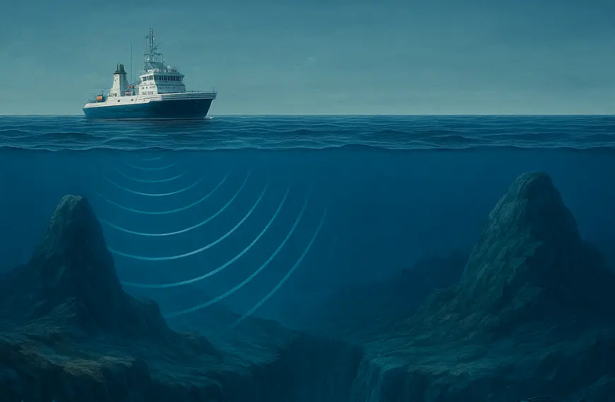
Sunlight penetrates only the uppermost layers of the ocean. Below that, crushing pressure makes diving impossible. We rely on sonar to listen to the landscape. Ships tow multibeam echo sounders that emit fan-shaped pulses, recording return times to measure depths. Over repeated passes, these instruments build swaths of data that form bathymetric mosaics.
Seamounts: Underwater Volcanoes
Seamounts are extinct volcanoes rising from abyssal plains. They number in the tens of thousands across the oceans. Some peak only 100 metres below the surface, while others reach up to 3,000 metres high. They break currents, drive nutrient upwelling, fuel plankton blooms and attract corals, sponges and fish.
The Emperor Seamount Chain in the Pacific stretches over 5,000 kilometres. It formed over a volcanic hotspot as the Pacific Plate drifted west. Now worn by erosion and subsidence, its peaks still sustain deep-sea biodiversity.
Canyons and Trenches: Submarine Valleys
On land, rivers carve canyons. Underwater, turbidity currents carry sediment down continental slopes, gouging deep channels. The Zhemchug Canyon in the Bering Sea is deeper and wider than the Grand Canyon, with walls that host cold-water corals and unique marine life.
Beyond canyons lie trenches, some deeper than Mount Everest is tall. The Mariana Trench plunges to 10,924 metres. Robots exploring the depths have discovered unusually large amphipods alongside plastic debris. The Challenger Deep remains among Earth’s last great frontiers.
Technologies of Exploration
Modern tools have transformed seafloor mapping. Multibeam echo sounders can cover swaths up to 10 kilometres wide, capturing high-resolution grids in shallow seas. Autonomous Underwater Vehicles map rugged terrain under ice shelves with centimetre accuracy. Satellite altimetry detects gravity anomalies on the ocean surface to infer underwater topography. Deep-sea remotely operated vehicles carry cameras and robotic arms to survey habitats and collect samples.
Biodiversity Hotspots
Mapping reveals ecosystems rich in life. Seamount summits host corals, sponges, lanternfish and tuna. Cold-water coral reefs thrive at depths of 400 to 1,000 metres in canyons like Whittard Canyon off Ireland, rivaling tropical reefs in biodiversity. Deep-sea vents and seeps, often linked to geological faults, sustain chemosynthetic organisms that survive without sunlight.
Human Impacts and Conservation
Fishing fleets target deep-sea species like orange roughy and Patagonian toothfish. Bottom trawling destroys fragile corals and sponges that take centuries to grow. Oil and gas exploration continues across continental shelves, while deep-sea mining proposals eye polymetallic nodules.
Marine protected areas depend on accurate maps. Initiatives like the Global Ocean Observing System and the Seabed 2030 project aim to map the entire ocean floor by 2030, guiding conservation and safe navigation.
The Commercial Frontier
Seafloor mapping supports cable routing for global internet networks, pipeline placement, submersible navigation and offshore renewable energy planning.
The Allure of Discovery
Each new map reveals hidden mountain ranges larger than the Alps, submerged ridges dividing oceans, ancient river valleys, and landscapes shaped by ice ages. Bathymetry preserves the story of Earth’s past.
Expanding the Map
Citizen scientists also contribute. Sailors and fishermen upload depth readings, while autonomous saildrones carry echo sounders. International collaborations are steadily filling in the blank spaces on our maps.
A Connected Planet
The seafloor shapes ocean circulation, climate regulation, nutrient flows and tectonic activity. Understanding it is vital to predicting natural hazards and managing marine resources. With each metre mapped, we discover new species, fragile ecosystems and insights that bring us closer to protecting both land and sea.


